Rebecca Wilks

Rebecca Wilks; Photographer, Teacher, Yarnellian, Do-Gooder

Tuesday, October 31, 2023

Back to Caddo


Reflections, Caddo Lake State Park, Texas

Perhaps I felt I had unfinished business in the bayous of East Texas, or maybe I just relished the opportunity to spend time with these two lovely friends. Normal girlfriends do spa days and shopping, but we prefer pulling on waders and paddling kayaks in the pre-dawn dark.  That sounds great, right?

 Caddo Lake, which straddles the Texas -Louisiana border, has become popular with photographers in recent years.  At the suggestion of Christie at River Bend Outfitters, we booked a week earlier than usual this year and found that we were almost always alone. What a joy!


Framed, Benton Lake, Texas

I found myself in search of new ways of looking at the breathtaking Spanish moss - draped cypress trees, hoping to create some original work.  Some of my ideas required fog (mist in East Texas vernacular), and in its absence during this unseasonably warm week I tried other things.


Wider perspective, Pine Island Pond Texas

I pulled out the wide angle lens a bit and did some different compositions.


Green Tree Frog, Star Ranch, Texas

When it was deeply overcast we all focused on details.  I’m often too impatient for wildlife photography, but the green tree frogs were kind enough to be still for me.


Detail, Turtle Shell Paddling Area, Texas

Sometimes there are small subjects that convey mood, like this lone hydrophobic water lily leaf.


Pine Island Pond, Texas

Reflections of the trees in the water can be spectacular, but sometimes distracting flotsam intrudes.  I hated to be repetitive as well, so I found myself looking for other foregrounds, like lily pads and these tiny floating heart flowers.  Unfortunately, they’re invasive in Texas.  I was willing to forgive them and was enchanted.


Pine Island Pond, Texas

Any excuse will do for black and white images, but the drama of the swamps suits particularly well.

 I think I might just return to the swamp before too long.


Tuesday, October 10, 2023

Snow on the Aspens!


Frost on the woodpile, Kaibab National Forest AZ

Yes, I still believe that it’s better to be lucky than good sometimes.


Frozen. Fish Lake National Forest, UT

We experienced the season’s first snow in southern Utah. On the aspens.  Yeah.  These are the times when I’m too excited and grateful to notice that I’m cold. The biggest challenge is choosing a favorite shot. 

Spotlight above Seven Mile Creek, UT

Snow and shifting light make everything more beautiful.  This is a favorite fishing spot for my husband.  I’ve shot there before, but it never hit me in the chest like this.

There were a few more notables.


Before and after.  Aerial images taken 9 days apart, Kaibab National Forest, AZ

We started in the North Kaibab Forest, north of the Grand Canyon.  I’ve been spending time there for many years but there are always new special places to discover.  Fall color arrived late there this year, so we decided to loop north into Utah and come back on the way home.  In truth there were great opportunities at both times.  These two drone images were taken 9 days apart in nearly the same location. The cold weather came on suddenly and things changed fast.

Just when I was reflecting on the timing and rapidity of the process this year, a link to a  fascinating post from Sara Marino landed in my inbox.  Among other things, she asserts that peak fall color doesn’t exist. She elaborates,

Many … are obsessed with the concept of peak fall colors, as if there is a single day in which a region looks its very best, and if you arrive before or after that day, you will essentially be wasting your time. The feeling of potentially missing “the best” conditions creates stress and anxiety, two emotions that are not conducive to creative thinking and can diminish the experience of being outside. The concept of peak fall color also assumes that all photographers are looking for the same thing and that there is a single definition of “best conditions.”  


Tree Skeletons as backdrop, Kaibab National Forest, AZ

There are so many opportunities in autumn aspen forests, from just-barely yellow to the contrast provided by bare trees and leaf carpets.  The rapid change is a gift reminding us to be mindful and to appreciate what’s in front of us.

Ice Puddle Reflection, Fish Lake National Forest, UT

Speaking of mindfulness, I stumbled on these frozen puddles in the Fish Lake National Forest shortly before the rising sun hit the trees behind.  I was so grateful to be in “the zone” and anticipate the reflections.

Frosty Flowers, Kaibab National Forest, AZ

The hoar frost on these flowers, remnants of summer in the Kaibab, stopped me in my tracks, too.

S-Curve aerial, Kaibab National Forest, AZ

This was my first autumn with the drone.  Several times we chose a campsite because it was outside the Grand Canyon no-fly zone.  I’d been dreaming of the top-down tree shots like this.

Moonset over Circle Cliffs, UT

When I started planning for the full moon, I decided on a departure from the high-altitude forests in Utah and camped near the Circle Cliffs in Grand Staircase Escalante National Forest.  The amazing eroded colorful and eroded bentonitic formations out there blow me away. The chance to enjoy warmer temperatures and thaw out wasn’t bad either.


Since we were in the neighborhood, we stopped for dinner at Hell’s Backbone Grill. Theirs is spectacular food in the middle of nowhere.  This was certainly a departure from the usual camping meals, but there are no rules, I say.

Dramatic light, Fish Lake National Forest

I’m a sucker for drama.  This example in the Fish Lake Forest made me glad I kept prowling around with my camera despite the temperature hovering around freezing all day.

Dawn on the Fremont River, UT

My husband was invited to fish on a private section of the Fremont River near Torrey Utah.  The plan was to drop him off and go exploring with Gypsy the Wonder Dog.  I’m glad I took a little walk around this beautiful spot first.

12 days on the road, gratitude, and luck.

Thursday, October 5, 2023

Hurling Your Camera Into the Air

This article was originally published in the October 2023 issue of Focal Points, the magazine of the Sierra Club Camera Committee.

Top-down composition of Granite Dells in Watson Lake, Prescott Arizona

How it Started

I know.  I hated the sound, too.  I’m still not so crazy about it if I’m honest. I didn’t think I’d ever want to fly a drone.  My husband bought this one with the holiday check that my mom sends.  Apparently, he knew better than I did.

The aircraft is a DJI Mavic 3.  It’s easy to fly out of the box, with features including GPS-enabled return-to-home and obstacle sensing. It sports a Hasselblad 20MP 4/3 CMOS camera with 12+ stops of dynamic range and a 24mm equivalent focal length.  There’s also a camera with 162mm equivalent focal length which I rarely use because of its lower resolution, though it can be useful for scouting.

Gold Butte National Monument, Nevada

I was thrilled to find that I felt comfortable flying the first time.  We were camping at Gold Butte National Monument.  The dramatic change in perspective (the “tall tripod”) blew me away.  At that point I was hooked.  Here’s my first image.  I certainly had a lot to learn. I still do, but looking at it brings back the thrill. 

Getting Started

It might be tempting to buy and fly, but there are important things to learn.  Many of them involve safety and government regulations. 

There are two ways to qualify with the FAA to fly a small (less than 55 pound) unmanned aircraft.  Recreational flying, under USC section 44809 will cover you if you’re just flying for fun. There’s a simple exam called “trust,” which will set you up with the basics of rules and regulations.

Commercial flight is covered by Part 107 (of Title 14, Code of Federal Regulations) and is required not only for paid work, but also work for barter or donated to or nonprofits, anything that’s not just for fun.  There is a loophole; you can get paid for drone work without having your part 107 if your original intent was recreational.  For example, you stumble on an important event while flying for fun and sell it to a local news station. However, that’s not going to work more than once or twice.

I work for Arizona Highways Magazine whenever they’ll have me and I do some work for nonprofits, so I did the Part 107 certification.  Even if you’ll only fly recreationally, more knowledge is almost always a good thing. Taking the test is worth the trouble.

The Part 107 exam is taken in a proctored location, and certification also requires a background check.  If you’re not already a pilot of a manned aircraft, you’ll likely benefit from a prep course to learn things like reading sectional charts, understanding airspace, and decoding aeronautical weather reports and forecasts.  I was glad to have chosen Pilot Institute’s (https://pilotinstitute.com) preparation course, but there are several other courses also available.  


Nonprofit Work: Aerial Group image of a hometown fundraiser, Yarnell Arizona

In addition to certification of pilots, registration is required for most unmanned aircraft, and there’s a separate registration for drones belonging to recreational vs commercial pilots.  The rules here are simple; any drone weighing more than 250 grams (just over half a pound) must be registered with the FAA. Under 44809 (one registration for each pilot, regardless of the number of aircraft) and a separate registration for each small, unmanned aircraft regardless of weight for part 107.

As of mid-September 2023, all drones are required to broadcast “remote ID,” which lets law enforcement (and unfortunately the public through a phone app) know who is flying the drone and from where.  Aircraft purchased after approximately September 2022 come with this capability, and older ones need a retrofit. Due to an outpouring of concerns, The FAA says that the deadline has not been changed, but they will not take enforcement action until March 16, 2024.
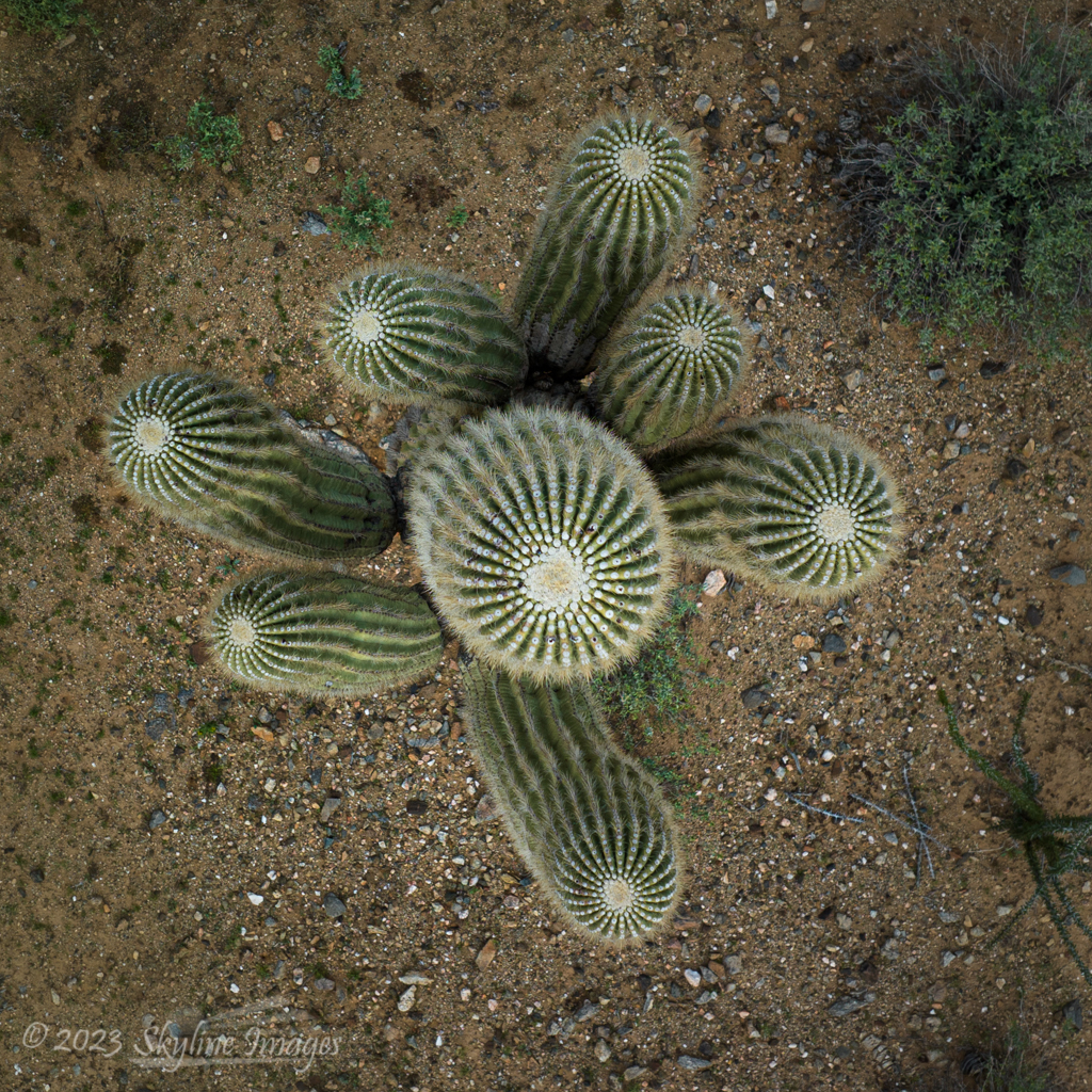
Top-down image of a Sahuaro Cactus, Maricopa County, Arizona

There are, as you might imagine, quite a few regulations regarding flight.  Here are the highlights. 

  • ·        The altitude limit is 400 ft above ground level (not above the pilot).
  • ·        The pilot or visual observer must be able to see the aircraft throughout the flight.
  • ·        Night flights are allowed under part 107 with proper anti-collision lights.
  • ·        There are places one can’t fly (National Parks and wilderness areas, for example), and places where permission is required (like within an airport’s airspace).
  • ·        Pilots are also responsible to be aware of Temporary Flight Restrictions (TFRs) – no-fly zones for things like the Super Bowl and Presidential travel. 
  • ·        Flying directly over people and moving vehicles is complicated in a regulatory sense.  The bottom line is usually to simply not do it.

Here’s another loophole: in most National Parks and wilderness areas, it’s legal to take off outside the boundaries and fly in.  I was advised to do just that by a ranger in one of the Mojave Desert federal properties.  However, just because you can doesn’t mean you should.  These restrictions exist for good reasons, and we should not be weenies.  Incidentally, Grand Canyon National Park is not included in this loophole.  They have a different kind of restricted airspace.

My van in a top-down campsite view, Along a tributary of the Salmon River, Idaho

Then there’s etiquette.  For example, don’t fly near enough to others to be annoying, and don’t even give the appearance of spying on people.  If folks ask you not to do something, comply if possible.

This video is a good place to start if you’re interested in more information:

There is an inordinate amount of anger out there about drones.  People sometimes feel that the aircraft threaten their privacy. We also hear the phrase “drone attack” on the news, leaving a less than positive feeling, even for the non-violent buzzers. It can be helpful to know something about the neighborhood you’re flying in.  There are more than a few cases of unmanned aircraft being shot down by the angry, and it’s a small consolation that that shooter, who is very unlikely to be caught, has committed a federal offense.

Sunflowers top-down

A word to the wise

I have a dorky dayglow yellow vest from Amazon.  On the back is printed “FAA Licensed drone pilot; do not disturb.” It gives me credibility, makes folks less likely to distract me with conversation while I’m flying, and makes me look like I’m supposed to be there. Recently, while photographing a sunflower field, a TV news drone pilot saw my vest and let me know he would be flying a drone nearby.  We were able to avoid each other. Communication makes this stuff safer for everyone.

Tributary in the Black River Watershed, White Mountains, Arizona

Taking good drone images

I’ve pondered and learned quite a bit about the ingredients of a good drone image.  The usual compositional principles apply, of course, but visualizing what you’ll see from the higher perspective takes experience.  Strong graphic content like rivers and other lines work well. 

Spring Cottonwood Trees in the Hassayampa River Valley, Arizona

Man-made structures in a mostly natural setting can be striking, especially when shooting straight down.  Shadows become especially compelling, as does color. All these things are helpful since creating image depth using prominent foregrounds is difficult from the air.
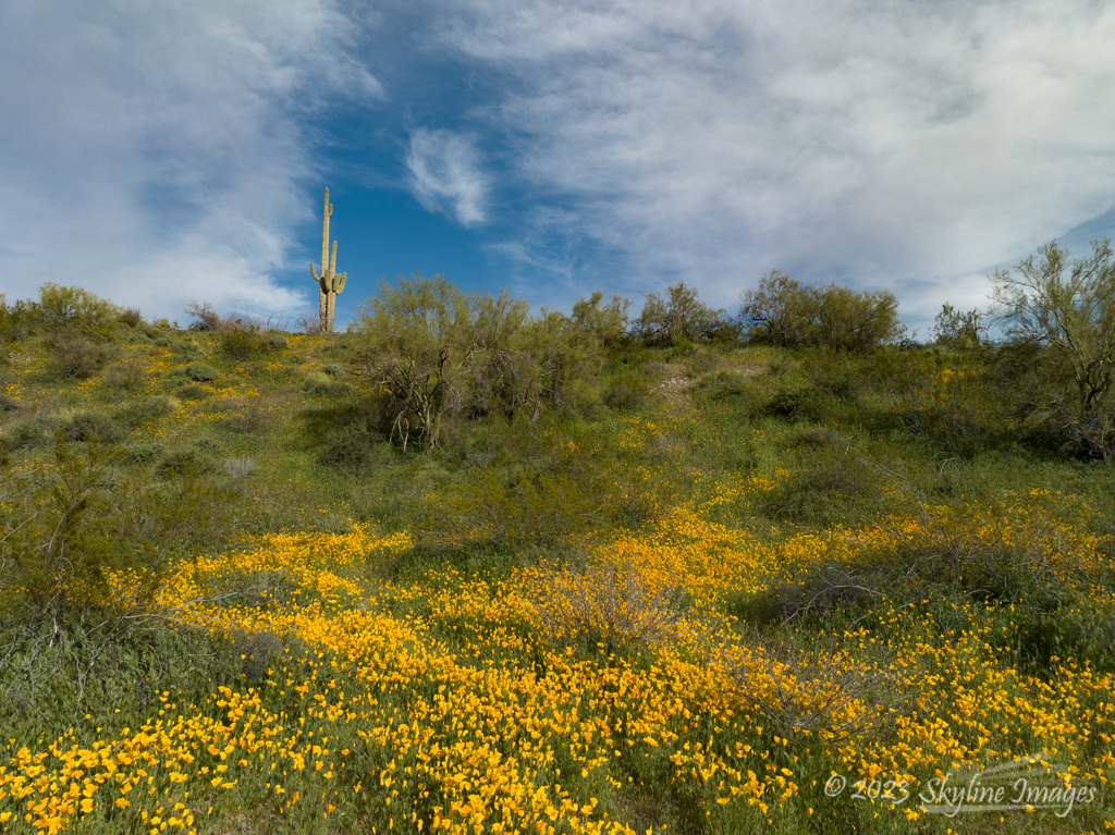
Spring Poppies and Sahuaro, Maricopa County Arizona

A common criticism is that many drone images are shot from too high a vantage point.  Like many questions of photography, I’d respond that “it depends.”  Sometimes we just want to get separation between our subject and the horizon, for example.  In these cases, we might need just a few feet of elevation, and the images might not look like it was taken from a drone.

Moki Dugway, Utah

For top-down compositions, though, I find that I often get close to that 400 foot above ground level limit before I like the image.  Here’s an example, shot of the Moki Dugway in Utah right at that elevation. I would have flown higher if I could.

Marco casting on the East Fork of Clear Creek, Arizona

People sometimes make compelling subjects as well.  Since my husband is an avid fly fisherman, I’m compiling an angler’s portfolio.  I appreciate the unique perspective from the aircraft.

What’s Next

My next impatiently anticipated project is shooting fall color from the air.  Wish me luck?

Monday, September 18, 2023

Departures


Partners in "Yarnell Loves Pets"

I’ve recently gotten interested in a couple of conservation projects in Prescott, about 35 miles from home.  The photographic work is a departure for me, and a great opportunity to think a little differently.

I’m grateful for the inspiration to “use my powers for good” from Russell Graves, a speaker at the North American Nature Photography Association last spring.  After that conference I started looking for causes to support with both drone and “ground” images.

Highway 89 Through the Granite Dells, Prescott AZ

There’s talk about widening a scenic stretch of Highway 89 in Prescott.  The project would involve blasting these majestic rocks, and I believe that’s a really bad idea.  In addition to photographs, I’ve had a few ideas to contribute, including some perspective on Highway 89, which stretches from the Mexican to Canadian Border (with a few interruptions) providing access to seven National Parks and fourteen National Monuments.  For most of its nearly 2,000 miles, it is a two-lane road. National Geographic named it the #1 Drivers’ Drive in the world. It’s about beauty, not speed.

Willow Lake near Highway 89 in Prescott AZ

A drone perspective conveys what a treasure this area is and must continue to be.

View from atop Glassford Hill into Prescott Valley AZ

There’s also a movement to designate Granite Dells Regional Park and Preserve, including Glassford Hill, an open area adjacent to Prescott Valley.  One of the largest enemies of that plan is a proposed road called the Sundog Connector running through the (now) open space.  I put the drone up to document the area around Glassford Hill to show the natural beauty of the area, and some destruction that’s already happened around its periphery. More information is available on the Sundog DISConnect Facebook page.

Meals on Wheels client and her beloved dog

Petey's Playground's Kim Lytle with an adoptable kitten

The third project is right here at home.  The Yarnell Regional Community Center’s main mission is Meals on Wheels, serving homebound clients in our rural area.  We’ve been supporting clients and their pets with the help of a grant from Meals on Wheels America and PetSmart Charities.  The program, deemed “Yarnell Loves Pets,” helps with anything from veterinary bills to pet food.  I’m honored to be a member of the group telling the story of this program, in hopes of raising awareness and, we hope, new funding to make it sustainable.

Some of these projects are too new to yet have a web presence, but I’ll edit this post to include URLs when they’re available.

 These departures have been invigorating. 

Sunset lights up falling rain, Mogollon Rim Country AZ

The other departure?  A camping birthday party on Arizona’s Mogollon Rim.  There wasn’t too much photography (wait, what?), but there was cake, and one unbelievable sunset.

Up next, the annual Fall Color pilgrimage to Northern Arizona and Southern Utah.

Saturday, August 26, 2023

Roadkill and Other Joys


Post-storm fog near Beartooth Pass Montana

This was a very different trip.

Warm Springs Creek's confluence with the Salmon River (roadkill)

 For one thing, there was a great deal of what I’ve heard Colleen Miniuk call “roadkill photography.”  Perhaps it’s not an original moniker, but I’ll give her credit for now. After a night’s rain, there was delightful fog over Beartooth Pass Montana and Wyoming.  We must have pulled over 10 times up and over the 11,000 ft summit. Besides that, there were scenes of ranching and farming life as well as details of the many watersheds we explored.

It’s a long way from Arizona to Montana. There were lessons learned on this 11 day, 3000-mile epic journey, not the least of which was that driving 6 hours each day is not ideal.  Next time, we’ll slow down by laying over in some camps for second nights and doing some shorter driving days.  Photographers among my readers will recognize this paragraph as an excuse for the relative paucity of images coming out of this undertaking.  No matter, we had fun.

Marco fishing the Yankee Fork of the Salmon River, Idaho

And there was fishing.


Campsite on a tributary of the Salmon River, Idaho

Finding a dispersed (outside a campground) camping site on the fly can be an adventure (read: pain in the butt), but we had expert advice from locals and photographer friends which led us to some of the best sites like this one, vaguely captioned to protect vulnerable terrain.

Sunrise on and reflection of Mount Bachelor, Idaho

The low point (perhaps some of you voyeurs want to know) was a camp spot without shade, which added insult to injury with hordes of insects not deterred by DEET.  The high temperature inside the van (my only refuge) was 97F.  I grumped.  This was sunrise the next day though, so perhaps it was worthwhile.

Detail of a hike near Red Lodge Montana


Our northernmost spot was driveway camping at the home of friends in Red Lodge, Montana, a relatively unspoiled mountain town (something like Crested Butte Colorado used to be).  We showered, did laundry, had leisurely meals and hikes and shopped the historic Main Street, where there may have been a thrift store, ice cream, AND a bakery.


Aerial, East Fork Bear River, Utah

As we worked our way home, and just before we re-entered familiar territory in Utah’s Uinta Mountains, we discovered the East Fork of Bear River.  We didn’t have time to linger, so we vowed to return. Unfinished business.


Storm over Marble Canyon, Arizona

To ground ourselves, we spent the last night in the very familiar North Kaibab Forest.  We chose a great place to watch storms pass which also has a phone signal (our first this trip, not counting Red Lodge) for a Zoom meeting.  We’d no sooner pulled into this familiar spot than the rainbows started.

 Thanks for your interest.  As always, more images are in the Summer 2023 Gallery on the website.

 Next up, the annual Autumn trip through Northern Arizona and Southern Utah.  I anticipate more drone flights above the aspens and less roadkill.