Rebecca Wilks

Rebecca Wilks; Photographer, Teacher, Yarnellian, Do-Gooder

Monday, October 24, 2016

Underground


Sapsucker Woods
Standing in that deep limestone gorge in Central New York, it occurred to me that this place is about as different from the desert southwest as it gets.  Despite what the locals are calling a severe drought (not quite as severe as Southern California), my shoes got well-coated in mud each day and the grasses are all thick and green.  It's all relative.


Contrasts are great for stirring up my creativity, as is the sense of awe when around each corner are mind-boggling colors and elegant waterfalls.


The finger lakes region of New York is peppered with "Glens," narrow valleys which generally contain watercourses.  Some of this year's locations were old friends and others were delightful new discoveries. 


As the old joke goes, they're all gorgeous.


These chasms are so narrow that they make me feel as if I’m shooting underground.


I have family in Ithaca New York, and they are enthusiastic, generous, and patient with all the standing around inherent in photography (at least we're going to lovely places), just not so much into leaving the house in the predawn dark.  I make those trips on my own and try to minimize the creaking I create on the stairs on the way out. 


Treman State Park
First on my list was Enfield Glen, part of Treman State Park.  My last autumn trip was in 2013 and the gorge was closed because it had washed out.  Treman has some of the best examples of the depression era stonework found in these parts.  I love the classic view of the stone bridge but never more than when the dark rocks are wet and covered with yellow leaves. Delightfully, I spent a couple of hours there and didn't see a soul.


Buttermilk Creek
Buttermilk Creek has been a perpetual favorite, and I was delighted that my brother and sister in law showed me yet another part of the drainage, made accessible because the dam-formed lake was much lower than usual.  This is a quiet area with striking reflections in the late afternoon.


Fillmore Glen
We took a day trip to Fillmore Glen (complete with the tiny cabin the president was born in), arranging to meet a photographer friend who fled Arizona for Syracuse a few years ago.  We had a lovely time gawking at and photographing the Glen.


Watkins Glen
My friend came back to Ithaca with us and the next morning we made an early trip to Watkins Glen State Park, perhaps one of the loveliest places I've seen.  I'd shot the obvious images before, so I also enjoyed carving out small details with a longer lens and playing with the really wide one.


For the sake of balance, I did want to shoot above ground as well.  On my mental shot list were a couple of ideas that I thought would tell some of the story of this region characterized by a string of villages connected by farmland.  I was delighted to find fields of hay bales on a backdrop of multi-colored hills near Newfield and a church steeple surrounded by resplendent hardwoods in the small town of Bath. There's something to be said for peppering my mind with ideas so I’ll be more likely to recognize an opportunity when I see one.


I’m back in the desert now and the high temperature today will be around 90.

More memories of the Finger Lakes are in the Northeast US Gallery on the Website.

Thursday, October 13, 2016

Trashed


Sunrise on the Mogollon Rim
I got thinking about this while cleaning up someone else’s leavings in my camp yesterday.  

I have come to love “dispersed camping.”  As long as I follow the rules of the particular Forest or BLM Unit, I can camp outside an established campground.  Generally this means solitude, quiet, and a sense of wilderness. Sometimes there are even spectacular views.

Now and again, though, the sites are a mess with scattered trash.  This last camp was in the Coconino National Forest along the Mogollon Rim.  This area, in my experience, is particularly trashy.  I’d correlate that with what I call a “high redneck quotient.”  For the sake of this argument, I’ll call a redneck someone who doesn’t care enough about the area to pick up their own waste; someone who considers the wilderness their personal garbage heap.

I have some thoughts about this.

Maples in the forest
I wouldn’t consider visiting these areas on a weekend or (heaven forbid) a summer holiday.  In addition to the garbage, they’re rife with loud ATVs going way too fast on one-lane dirt roads, RVs running generators, and target practice.

"Lurch," my camping rig on the Mogollon Rim
That being said, camping in cute trailers, tricked-out vans, and rigs like mine is enjoying a huge resurgence.  Some all this the “Home is where you park it” movement. True, this creates greater crowds, but by and large these folks are respectful and quiet.

I fear that there’s some correlation between the rednecks and a growing trend toward defacing natural areas.  

There’s been a flood of stories about (for example) “artwork” painted on rocks in National Parks, Sharpie graffiti in our own West Fork (Sedona), driving on the fragile playa in Death Valley, and the destruction of fragile rock formations.  I confronted a teenager carving his name in a slot canyon while his mom was RIGHT NEXT TO HIM.

Yellow maple fisheye
Somehow we’re less respectful of our natural areas and of each other.  We seem not to understand the long-term consequences of our destruction.  Yes, we can pick up trash and recycling as we move through the forest, but what can we do about a hoodoo toppled over at Goblin Valley?

I can’t offer a coherent theory about this selfish behavior, but I’m quite interested in your thoughts.

Meanwhile, I carry extra trash bags and stay home weekends.

I hope the images create some counterpoint  to the unattractive aspects of this post.  

Saturday, October 1, 2016

A Real Emergency Trumps a Fake One; Tales From the Road


Hmm.  Did I make you curious?   

The last afternoon of my just-completed week long road trip was reserved for an odd volunteer experience.  I was to pretend to be a victim in a Mass Casualty Incident Drill (MCID) at the Grand Canyon (South Rim) Emergency Response Station.  The timing was perfect to do this on the way home, and it sounded like a fun, unusual experience.  I came down from the North Rim the day before and had a chance to photograph several times before the drill.  More on that later. 

I met my fellow victims, with whom I was to fake injuries after a fake collision with a fake school bus.  The bus passengers would be played by students from the local high school.  I anticipated fake blood and maybe even a fake fracture.  The point is to create fake chaos for the trainees, and to provide feedback afterward on their performance.  Fun, right?

Waiting for the final details, we heard a call on the radio about a real emergency; a hiker had apparently had a heart attack on the Bright Angel Trail.  The Drill was cancelled as the instructors, the real rescuers, went to this person’s aid.  

Real trumps fake.

"Mushroom City," Bisti Badlands
This trip started at Bisti Badlands, a fascinating moonscape on BLM land in northwestern New Mexico.  I joined a camping trip & workshop with Colleen Miniuk-Sperry and sponsored by Arizona Highways Photo Workshops.  I’d never been there and especially appreciated the guidance.  Apparently people get lost here regularly.  The comradery was great, though I did feel a little guilty, warm in my camper when several of my new friends were in tents.  The low temperature was 34F.   In my own defense, I did lend out my spare sleeping bags.  We had some minor hardships; rain Friday made a bit of a muddy mess and the large group size, unfortunately the norm for AZHPW, can be frustrating as I frequently abandoned compositions because there were people in them, or because others asked me to move out of theirs.

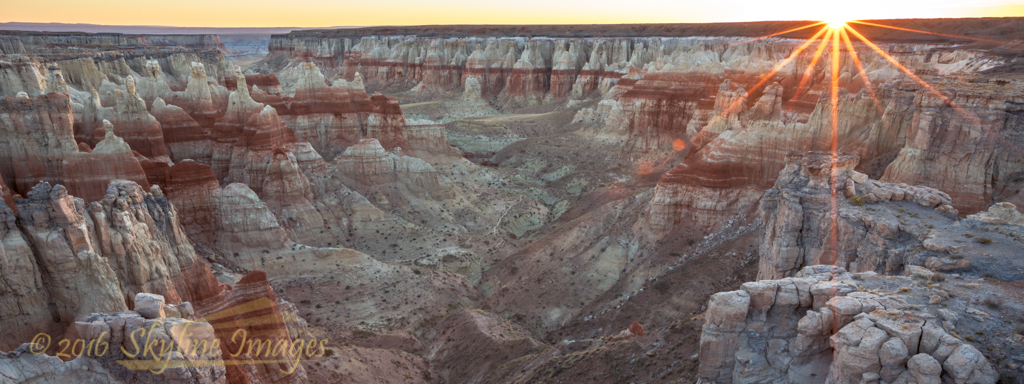
Coal Mine Canyon
So, I was ready to change gears and travel on my own.  Next stop, Coal Mine Canyon on the Navajo Reservation.  This beautiful spot requires a permit from the Nation, but I appreciated camping alone on the brink of the canyon, and especially the sunrise light.

Aspens, Kaibab National Forest
This was my last trip of the season to Grand Canyon North Rim, which closes November 15 or with the first major storm (whichever comes first).  I thought I’d be a little early for peak fall color but as it turns out the timing was just right.  I drove out FR 610 looking for the aftermath of the Fuller Fire.  The most striking thing was ten-plus miles of shredded forest along the road, the fire break created last summer.  I do understand the need for this, but am still rather sad about the damage to one of my favorite spots.

Last light from Fire Point
Fire Point is a fabulous forested remote spot on the North Rim. Most of the 17-mile dirt road drive is in the National Forest, but the last mile is National Park.  That last mile was never good, but has deteriorated quite a bit since last season, including impressive muddy quagmires.  I was commenting on the change to a British Expat I met out there when he told me that he last found this spot 25 years ago.  Apparently the “road” was hardly discernible then.  Here I found peace and an amazing nap.  I sketched out a list of adventures I’d like to have at the North Rim next season.

Rainbow at Desert View
Finally, I set up at Desert View, on the Eastern part of the South Rim. I love this spot, both for the views of the Colorado River upstream and for the namesake watchtower, designed by Mary Colter for the Fred Harvey Company.  Thunder started as I was setting up camp, and soon I was getting drenched on the rim of the Canyon, my mind blown away by sheets of rain, crazy light, and rainbows.  I’ve written about photogasms before, and I’ll have to add this afternoon to my list.  The following morning at Lipan Point was magical as well with breathtaking Grand Canyon fog. 

Real experiences, all.  Thanks for coming along.