This article was originally published in the October 2023 issue of Focal Points, the magazine of the Sierra Club Camera Committee.
 |
| Top-down composition of Granite Dells in Watson Lake, Prescott Arizona |
How it Started
I know. I hated the sound,
too. I’m still not so crazy about it if
I’m honest. I didn’t think I’d ever want to fly a drone. My husband bought this one with the holiday
check that my mom sends. Apparently, he
knew better than I did.
The aircraft is a DJI Mavic 3. It’s
easy to fly out of the box, with features including GPS-enabled return-to-home
and obstacle sensing. It sports a Hasselblad 20MP 4/3 CMOS camera with 12+
stops of dynamic range and a 24mm equivalent focal length. There’s also a camera with 162mm equivalent
focal length which I rarely use because of its lower resolution, though it can
be useful for scouting.
 |
| Gold Butte National Monument, Nevada |
I was thrilled to find that I felt comfortable flying the first
time. We were camping at Gold Butte
National Monument. The dramatic change
in perspective (the “tall tripod”) blew me away. At that point I was hooked. Here’s my first image. I certainly had a lot to learn. I still do, but
looking at it brings back the thrill.
Getting Started
It might be tempting to buy and fly, but there are important things to
learn. Many of them involve safety and
government regulations.
There are two ways to qualify with the FAA to fly a small (less than 55
pound) unmanned aircraft. Recreational
flying, under USC section 44809 will cover you if you’re just flying for fun.
There’s a simple exam called “trust,” which will set you up with the basics of
rules and regulations.
Commercial flight is covered by Part 107 (of Title 14, Code of Federal
Regulations) and is required not only for paid work, but also work for barter
or donated to or nonprofits, anything that’s not just for fun. There is a loophole; you can get paid for
drone work without having your part 107 if your original intent was
recreational. For example, you stumble
on an important event while flying for fun and sell it to a local news station.
However, that’s not going to work more than once or twice.
I work for Arizona Highways
Magazine whenever they’ll have me and I do some work for nonprofits, so I
did the Part 107 certification. Even if
you’ll only fly recreationally, more knowledge is almost always a good thing.
Taking the test is worth the trouble.
The Part 107 exam is taken in a proctored location, and certification
also requires a background check. If
you’re not already a pilot of a manned aircraft, you’ll likely benefit from a
prep course to learn things like reading sectional charts, understanding
airspace, and decoding aeronautical weather reports and forecasts. I was glad to have chosen Pilot Institute’s (https://pilotinstitute.com)
preparation course, but there are several other courses also available.
 |
| Nonprofit Work: Aerial Group image of a hometown fundraiser, Yarnell Arizona |
In addition to certification of pilots, registration is required for most
unmanned aircraft, and there’s a separate registration for drones belonging to
recreational vs commercial pilots. The
rules here are simple; any drone weighing more than 250 grams (just over half a
pound) must be registered with the FAA. Under 44809 (one registration for each
pilot, regardless of the number of aircraft) and a separate registration for
each small, unmanned aircraft regardless of weight for part 107.
As of mid-September 2023, all drones are required to broadcast “remote
ID,” which lets law enforcement (and unfortunately the public through a phone
app) know who is flying the drone and from where. Aircraft purchased after approximately
September 2022 come with this capability, and older ones need a retrofit. Due
to an outpouring of concerns, The FAA says that the deadline has not been
changed, but they will not take enforcement action until March 16, 2024.
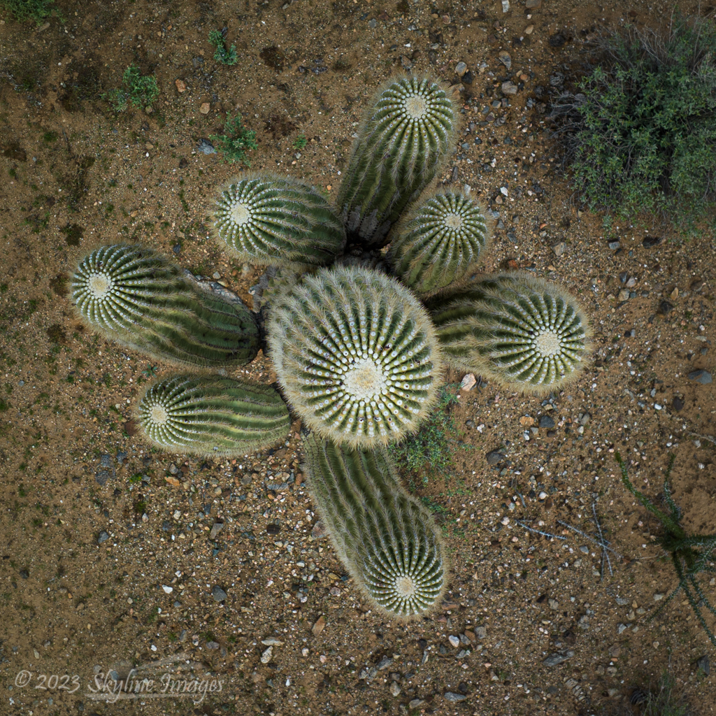 |
| Top-down image of a Sahuaro Cactus, Maricopa County, Arizona |
There are, as you might imagine, quite a few regulations regarding
flight. Here are the highlights.
- ·
The altitude limit is 400 ft above ground level (not
above the pilot).
- ·
The pilot or visual observer must be able to see the
aircraft throughout the flight.
- ·
Night flights are allowed under part 107 with proper
anti-collision lights.
- ·
There are places one can’t fly (National Parks and
wilderness areas, for example), and places where permission is required (like within
an airport’s airspace).
- ·
Pilots are also responsible to be aware of Temporary
Flight Restrictions (TFRs) – no-fly zones for things like the Super Bowl and
Presidential travel.
- ·
Flying directly over people and moving vehicles is
complicated in a regulatory sense. The
bottom line is usually to simply not do it.
Here’s another loophole: in most National Parks and wilderness areas,
it’s legal to take off outside the boundaries and fly in. I was advised to do just that by a ranger in
one of the Mojave Desert federal properties. However, just because you can doesn’t mean you
should. These restrictions exist for
good reasons, and we should not be weenies. Incidentally, Grand Canyon National Park is not
included in this loophole. They have a different
kind of restricted airspace.
 |
| My van in a top-down campsite view, Along a tributary of the Salmon River, Idaho |
Then there’s etiquette. For
example, don’t fly near enough to others to be annoying, and don’t even give
the appearance of spying on people. If
folks ask you not to do something, comply if possible.
This video is a good place to start if you’re interested in more
information:
There is an inordinate amount of anger out there about drones. People sometimes feel that the aircraft
threaten their privacy. We also hear the phrase “drone attack” on the news,
leaving a less than positive feeling, even for the non-violent buzzers. It can
be helpful to know something about the neighborhood you’re flying in. There are more than a few cases of unmanned
aircraft being shot down by the angry, and it’s a small consolation that that
shooter, who is very unlikely to be caught, has committed a federal offense.
 |
| Sunflowers top-down |
A word to the wise
I have a dorky dayglow yellow vest from Amazon. On the back is printed “FAA Licensed drone
pilot; do not disturb.” It gives me credibility, makes folks less likely to
distract me with conversation while I’m flying, and makes me look like I’m
supposed to be there. Recently, while photographing a sunflower field, a TV
news drone pilot saw my vest and let me know he would be flying a drone
nearby. We were able to avoid each
other. Communication makes this stuff safer for everyone.
 |
| Tributary in the Black River Watershed, White Mountains, Arizona |
Taking good drone images
I’ve pondered and learned quite a bit about the ingredients of a good
drone image. The usual compositional
principles apply, of course, but visualizing what you’ll see from the higher
perspective takes experience. Strong
graphic content like rivers and other lines work well.
 |
| Spring Cottonwood Trees in the Hassayampa River Valley, Arizona |
Man-made structures in a mostly natural setting can be striking,
especially when shooting straight down.
Shadows become especially compelling, as does color. All these things
are helpful since creating image depth using prominent foregrounds is difficult
from the air.
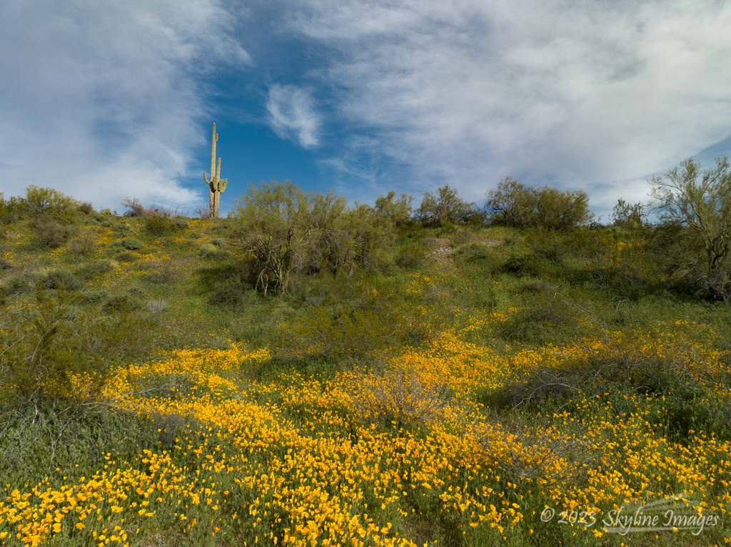 |
| Spring Poppies and Sahuaro, Maricopa County Arizona |
A common criticism is that many drone images are shot from too high a
vantage point. Like many questions of
photography, I’d respond that “it depends.”
Sometimes we just want to get separation between our subject and the
horizon, for example. In these cases, we
might need just a few feet of elevation, and the images might not look like it
was taken from a drone.
 |
| Moki Dugway, Utah |
For top-down compositions, though, I find that I often get close to that
400 foot above ground level limit before I like the image. Here’s an example, shot of the Moki Dugway in
Utah right at that elevation. I would have flown higher if I could.
 |
| Marco casting on the East Fork of Clear Creek, Arizona |
People sometimes make compelling subjects as well. Since my husband is an avid fly fisherman,
I’m compiling an angler’s portfolio. I
appreciate the unique perspective from the aircraft.
What’s Next
My next impatiently anticipated project is shooting fall color from the
air. Wish me luck?


